
Datei:Uganda Protectorate British administration.png

Greßi vu däre Vorschau: 528 × 600 Pixel. Wyteri Ufflösige: 211 × 240 Pixel | 422 × 480 Pixel | 661 × 751 Pixel.
Originaldatei (661 × 751 Pixel, Dateigrößi: 18 KB, MIME-Typ: image/png)
| Die Datei un d Informatione derzue were us em zäntrale Mediearchiv Wikimedia Commons (Allmänd) iibunde. | Zur Bschriibigssite uff de Allmänd |
Bschryybig
| Bschryybig |
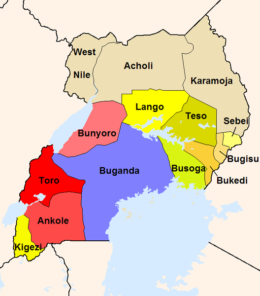
English: The map shows the British administration units in the Uganda Protectorate (borders of 1926).
The reddish areas and the blue Buganda are areas, where traditional kingdoms were maintained. In the yellowish areas Baganda-type administration was introduced. The khaki areas had no sole traditional rule before. |
| Quälle |
Eigeni Arbet
|
| Urheber | Slomox |
Lizänzierig
| Ich, dr Urheberrächtsinhaber vu däm Wärch, tue s as gmeinfrej vereffentlige . Des giltet wältwyt. In mänke Staate chennt des rächtli nit megli syy. Wänn des imfall eso isch: Ich gib e jedem s bedingiglos Rächt, des Wärch jedwädere Zwäck z nutze, ußer s git gesetzlig erforderligi Bedingige. |
Dateiversione
Klick uf e Zytpunkt zu aazeige, wie s dert usgsäh het.
| Version vom | Vorschaubild | Mäß | Benutzer | Kommentar | |
|---|---|---|---|---|---|
| aktuell | 02:44, 22. Feb. 2008 | | 661 × 751 (18 KB) | Mahahahaneapneap | pngcrushed |
| 22:34, 18. Sep. 2005 |  | 661 × 751 (34 KB) | Slomox | little correction | |
| 21:36, 18. Sep. 2005 |  | 661 × 751 (33 KB) | Slomox | The map shows the British administration units in the Uganda Protectorate (borders of 1926). The map is based on data given in ''A History of East Africa'' by Odhiambo, Ouso and Williams. The reddish areas and the blue Buganda are areas, where traditiona |
Verwändig vu dr Datei
Di folgende Sytene händ en Link zu dem Bildli:
Wältwyti Dateinutzig
Die andere Wikis bruche die Datei:
- Gebruch uf de.wikipedia.org
- Gebruch uf en.wikipedia.org
- Gebruch uf es.wikipedia.org
- Gebruch uf fr.wikipedia.org
- Gebruch uf io.wikipedia.org
- Gebruch uf it.wikipedia.org
- Gebruch uf ja.wikipedia.org
- Gebruch uf lt.wikipedia.org
- Gebruch uf no.wikipedia.org
- Gebruch uf pt.wikipedia.org
- Gebruch uf ru.wikipedia.org
- Gebruch uf uk.wikipedia.org
- Gebruch uf vec.wikipedia.org